 Bajram Curri -Dragobi-Valbone-Rragam-Thethi
Zone: Valbona valley
Tour type: Easy climbing, partially difficult at the e nd of the Tour
For childs: Childs to 14 years with an adult.
Rajoni:
Marvellous varied mountainous view, in background a passage of a fluvial view, field view to a hilly one.
United with water sources, cataract, snow slippery, greenness diversity etc. with new snow in winter and old snow in summer. With freshness climate
Best time:
May until end of September
Difficulty rating: easy, partially difficult
Start altitude: 390 meter Hotel B.Curri
Climbing altitude: 1900 meter Valbona saddle
Description:
For the realization of the guide of Valbona valley exist these possibilities:
1.The guide starts with car, bike or on foot from Hotel Turizmi B.Curri and ends in Valbona village (Gjese sources). From there we can go in Rragam village to climb Valbona saddle and through Valbona saddle down to Shala valley (Thethi alpine village)
2.If our journey is by car until we reach Valbona (Gjese sources), it can be possible that the trip can be completed in one day.
3.If our journey is by bike until we reach Valbona, it can be possible that the guide can be realized only to Rragam village and find accommodation for a few days in villagers houses in Valbona or Rragam and further movements in the two mountainous parts of Valbona valley and if is requested we can climb Rosi peak 2519m, Zhabores2561m, Brinjasit2529m, Paplukes2575m,Jezerces 2692m, Kollata 2554m.The comeback is the same, from B.Curri and further with ferry to Koman and from Koman to Rinasi airport(Tirana), Podgorica airport(Montenegro) or in Durres port Albania or Bari (Montenegro).
Start:
The guide starts from 390 m quota in B.Curri and decline in Valbona canyon to 297m further gradual climbing in Dragobi 568m,Valbona alpine center 746m , Valbona village 940m Rragam village 1030m
The trip last about 20km and is not asphalted road and you can reach Valbona village with all kinds of vehicles.
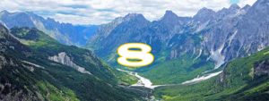
Attached photos show a part of the guide B.Curri-Rragam
Equipment:
Alpine equipment ,alpine shoes, warm clothes, climbing-irons, safety equipment.
Literature:
Tourist, Climbing, Physic geography
Maps:
Topographic map, scale 1:25 000,1:50 000 of Alps
(1:25 000)
(1:50 000,Shkodra,Puka,Bajrram Curri,Tamara)
Road length B.Curri-Thethi:
Total: 34.5 km
From which:
20km with car
4.5km mountainous walking
10km alpine land