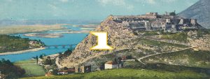
Paqe village (Buna bridge)-Tarabosh mountain-Suka mountain-Zogaj-Shiroke-Buna-Drini conflux –Shkodra castle
Zone: Tarabosh mountain-Zogaj-Shiroke
Tour type: Low mountainous climbing, medium partially lowering to Zogaj village.
For Childs: Childs up to 14 years with an adult.
Region:
Marvelous varied mountainous view in background a passage of a fluvial view, a lake view, field view to a hilly one,
United with a greenness diversity etc.
Best time:
April until October end.
Difficulty rating: easy, partially medium
Start altitude: 25meter Paqe village (Buna Bridge)
Climbing altitude: 651 meter Golishti peak
Description:
For the realization of the valley of Taraboshi mountain guide exist this possibilities:
The guide starts on foot or in bike starting from Paqe village (Buna bridge) riding gradually according to the roadway that passes near Taraboshi antenna going up in Bajraku peak 395m , and then continue through the road Taraboshi peak 594.2m and Golishti peak 651m and in the end going down in direction of Zogaj village with about 10m quote from the point that the guide continues near Shkodra lake through the roadway Zogaj-Shiroke-Buna bridge-Buna river Drini river conflux (Enigma Restorant)-Buna bridge-Shkodra castle.
In Zogaj village is located a mosque also a little traditional souvenir center and the fishing center here is located the last stand of bus-line Zogaj-Shiroke-Shkoder.
In all the road Zogaj-Shiroke-Buna bridge-Buna river Drini river conflux there are a lot of different restaurants which cook Shkodra lake fish also Buna and Drini fish.
Near Buna river is located a mervelous geotop where we can see clearly the mount of carbonic rocks triasik age (205-250million years) of the tectonic zone of Albanian alps over the flish alevro formation with an age paleocen-eocen,Pg1-2(37-65million years) of Krasta tectonic zone(pic.10)
Start:
The guide starts on 25meter quota on Paqe village (Buna bridge) and arrive on 651 m Golishi mountain and lower in 10m in Zogaj and later go up to 120m quota in Shkodra castle.
Equipment:
Light alpine equipment ,alpine shoes, warm and light wearing
Literature:
Tourist, Climbing, Physic geography
Maps:
Topographic Map scale 1:25 000,1:50 000 of Alps
(1:25 000 Shiroka)
(1:50 000, Shiroka)
Road length Paqe village (Buna bridge)-Rozafa castle (Shkodra)
Total: 22 km
From which:
10km – mountainous walking
12km – plain field