 Shkoder-Koplik-Hoti-Rrapsh-Tamare-Vukel-Nikç
Zone: Shkoder-Koplik-Hot-Tamare-Vukel
Tour type: Easy climbing,partialy difficult at the end of the Tour
, movement is done along Cemi of Vukli’s river valley.
For childs: Childs to 14 years with an adult.
Marvelous varied mountainous view, in background a passage of a fluvial view, field view to a hilly one.
United with geological phenomenon , greenness diversity etc., With freshness climate
Best time:
May until end of September
Difficulty rating: easy, partially difficult at the end of the tour
Start altitude: 25 meters Paqe village (Buna bridge)
Climbing altitude: 628 meters Nikç
Description:
For the realization of the guide exist these possibilities:
1.The guide starts with car, motorbike or bike from Paqe village (Buna bridge) and ends in Nikç village. The road is paved from Shkodra till Rrapsh-Starja villages then is not asphalted but good till Tamara a little mountainous, not asphalted through Vukel till Nikç.
2.If our trip is by car till upper Hoti the guide can be continued on foot or bike according to the roadway till Tamara where are offered possibilities of accommodation or finding accommodation a few days in the villagers houses or a tent camp. Leqet e Hotit display a paradise for the sport of cycling.
Tamara offers good possibilities for summer rock climbing and possibilities for the sport of kayaks, fishing in Cemi river. Then continue on foot, or with vehicles to the pictorial villages of Vuklit and Nikçit. There are good possibilities of accommodation or finding accommodation a few days in the villagers houses or a tent camp where can climb the peaks around the village.
Start:
The guide starts from quota 25 m Paqe village (Buna bridge) then gradual climbing to Leqet e Hotit 735 ,go down to the alpine center Tamare 262 m , then starts gradual climbing to Kozhnja 470m, Vukel 541m Nikç village
628m Nikç.
The road last about 87km from which 46.5 km is paved and the remaining part is not asphalted, Vermoshi can be reached by all kind of vehicles.
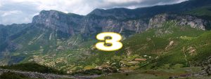
Attached photos show a part of the guide Shkoder-Vermosh
Equipment:
Alpine equipment, alpine shoes, warm clothes, climbing-irons, safety equipment.
Literature:
Tourist, Climbing, Physic geography
Maps:
Topographic map, scale 1:25 000,1:50 000 of Alps
(1:25 000.)
(1:50 000,Shkodra,Puka,Bajrram Curri, Tamara)
Road length Shkoder- Nikç:
Total: 67.0 km
From which:
46.5km with car
20.5km mountainous walking